Short question: Do apps work with a higher version of CUDA if they specified a lower version as requirement? Or should I exactly match the version?
Extra explanations: I want to use GPU in TF and Matlab. The first one says I need CUDA 11.2 and the second one mentions CUDA 10.1. Currently the latest available CUDA drivers are 11.6.1. Can I just install the latest version and hope they all work well?
I am trying to run a project which only supports tf 2.2, but I have CUDA 11.x which is not supported by TF 2.2 for GPU support. Is there a way to install CUDA 10.1 and 11.6 and switch between them?
Edit: RTX 3xxx support CUDA 11.x. The repository (Mask R-CNN support TF 2.2, which works with CUDA 10.x for GPU support). I realise I cannot train with GPU…
Gil Makleff and Artem Koren are developing AI for meeting transcripts, creating time-savers like shareable highlights of the text that is often TL;DR (too long; didn’t read). The Sembly founders conceived the idea after years of working in enterprise operational consulting at UMT Consulting Group, which was acquired by Ernst & Young. “We had an Read article >
Talk about a bright idea. A team of scientists has used GPU-accelerated deep learning to show how color can be brought to night-vision systems. In a paper published this week in the journal PLOS One, a team of researchers at the University of California, Irvine led by Professor Pierre Baldi and Dr. Andrew Browne, describes how Read article >
I’m thinking of making an Arduino based program where it captures audio from me or someone saying something or playing something on a musical instrument, and uses that to check similarities between a database of audio files I’ve created using TensorFlow. Is this possible with TensorFlow and Arduino? Thanks!
Cities now have access to real-time, multimodal traffic data that improves road safety and reduces traffic congestion.
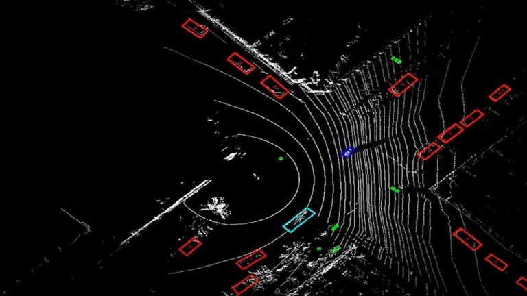
Bluecity, an NVIDIA Metropolis partner, recently launched a new traffic management solution for safer roads and shorter commutes. The technology combines vision AI and lidar technology to better understand round-the-clock traffic data, providing information that could help city planning departments identify problem intersections, reduce congestion, plan smarter, and lower emissions.
Road safety and congestion are a priority for city and transportation planners, but sparse data has limited their ability to address traffic issues, especially in areas with ever-expanding populations. While video cameras are used to capture information, like the number of cars at a particular intersection, poor lighting and bad weather conditions can interfere with capturing this data accurately. Studies have also shown that accidents are most likely to happen during those times when visibility is low.
New technologies that can overcome these obstacles and collect multimodal data about drivers, vehicle speed, and trajectories can help make the roads safer. Especially when it can be done in real time.
Bluecity is solving this problem by combining vision AI and lidar technology to understand and evaluate traffic data.
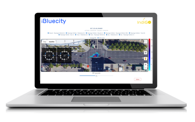
Figure 1. Bluecity analytics platform
Similar to radar, lidar sensors emit pulsed light waves into the environment and sense objects when the pulses bounce off them. Lidar uses lasers with a lower wavelength than radar, and as a result can detect smaller objects, offering precise measurement data. Lidar can do this even in poor lighting or weather conditions and it captures data anonymously. Each lidar sensor can provide 360-degree coverage and a radius of up to 120 meters (400 feet).
The Bluecity system employs the powerful capabilities of the NVIDIA Jetson edge AI platform—which provides GPU-accelerated computing in a compact and energy-efficient module—along with NVIDIA TensorRT to accelerate its application’s inference throughput at the edge. The edge computing system runs a proprietary 3D perception software and powers the traffic management solution to process up to 50 lidar frames per second in real time to detect all road users.
Their platform provides information on which turning directions and intersections are the riskiest, near misses, time-to-collision, and the speed of the vehicles involved. It can also classify road users and gives important insight into not only driver behavior, but also that of cyclists and pedestrians.
The ability to collect data regardless of lighting or weather conditions helps city planners make decisions about things like road design and traffic-light timing that are based on actual data. The startup’s AI component turns raw data into valuable information that guides practical and timely decision-making. AI powers better visualization, while conflict analyses help identify dangerous intersections before accidents occur. For instance, in Repentigny, Quebec, Bluecity installed their solution to provide multimodal traffic data so an engineering firm could better understand mobility in a region where they are updating a bridge.
Subscribers can view, select, filter, and download the data in order to improve their traffic planning with Bluecity’s easy-to-understand dashboards.
Bluecity solutions are deployed in several Canadian, U.S. and European cities, including Irvine, Austin, Texas, Boca Raton, Trois-Rivières in Canada, and Helsinki, Finland. The startup’s vision is to provide better multimodal data to make intersections in our cities safer, improve road safety, and lead to reduced carbon emissions for smart cities.
This GFN Thursday delivers more gr-EA-t games as two new titles from Electronic Arts join the GeForce NOW library. Gamers can now enjoy Need for Speed HEAT and Plants vs. Zombies Garden Warfare 2 streaming from GeForce NOW to underpowered PCs, Macs, Chromebooks, SHIELD TV and mobile devices. It’s all part of the eight total Read article >
I am trying to create a hand pose classifier on Tensorflow.js using JS. I am familiar with the libraries that make hand pose classification possible, but they all support only one hand. I want to train a neural network using landmarks from both hands (or classify each hand seperately) and ideally save and use that dataset on a web-based project. Can anyone point me in the right direction/tutorials to implement this idea?

 Cities now have access to real-time, multimodal traffic data that improves road safety and reduces traffic congestion.